

 |
Feature Points. Examples: marker buoy, transponder, other fixed geography. |
 |
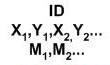
Instantaneous Point. Examples : CTD, XBT, SVP, fish density, tide gauge, etc. At surface or a single Z. |
 |
Location Series Point. Examples: telemetry, bird/mammal sighting, ship mounted ADCP. |
 |
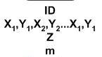
Time Series Point. Examples: Current meter at moored ADCP, obs. buoy, hidrophone, OBS at single. |
 |
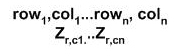
Data Line. Examples : Cross-section, bathy profile, sed transport line. |
 |
Time Duration Line. Examples: Algal bloom trawl, ADCP tracks, ARGO drifter. Track |
 |
Feature Line, Examples : cable, pipeline, sea wall, ocean front, EEZ, legal boundaries, shoreline. |
 |
Feature Area : Examples : Morine boundaries,
habitats, patches, lava flows, etc.
Sea regions: |
 |
Time Duration Area. Examples : No-take zones, oil spills, harmful algal bloom. |
 |
Regurlarly Interpolated Surfaces. Examples: bathymetry, sidescan, SST, climatology, images... |
 |
Irregularly Interpolated Surfaces. Examples: TINs, batymetry. |
 |
Volumes. Examples : plume front, warm core, trawl abundance |
 |
Animations, Movies, Videos |
| Fotos | |